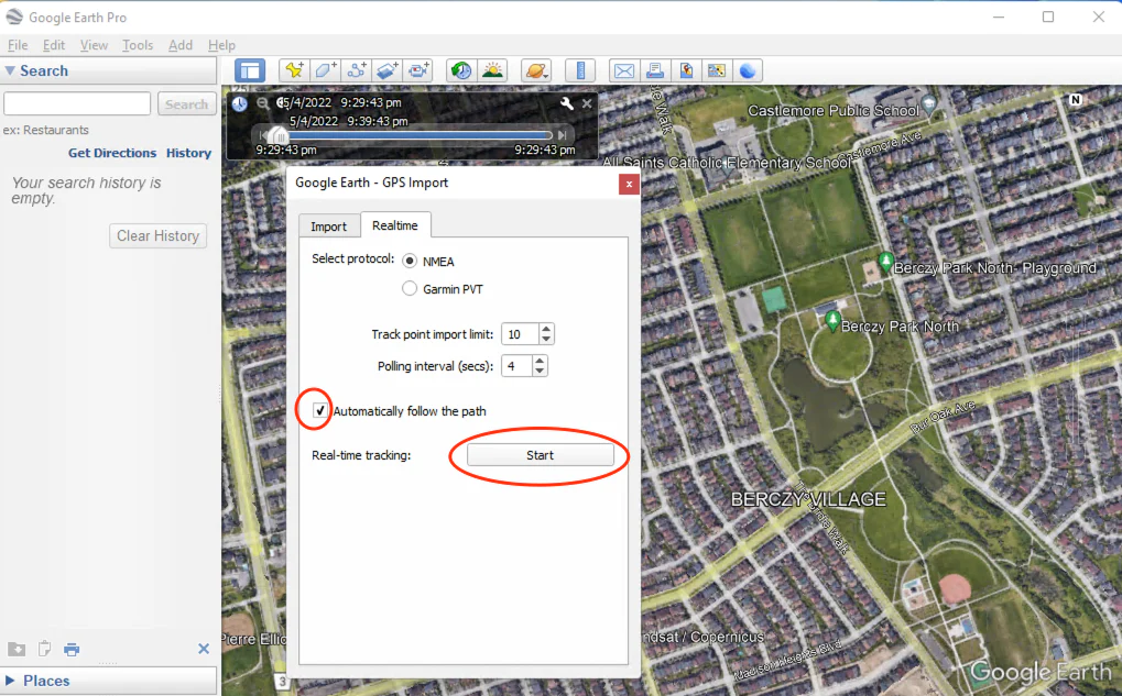
Once you have successfully connected your GPS/GNSS receiver to Windows, you can open the “Google Earth” application. To configure the GPS settings, go to the Google Earth menu and click on “Tools” followed by “GPS”. This will open the “Google Earth – GPS Import Windows” window. In the “Realtime” tab, select “protocol: NMEA” from the drop-down menu. Additionally, check the box for “automatically follow the path” and then click on the “Start” button. Please refer to the screenshot below for further guidance.
Google Earth will initiate a scan of all “COM” ports to locate the GPS receiver. Once it detects NMEA data being transmitted from the “COM” port associated with the GPS receiver, it will read the data and display the current location in Google Earth.
We have tested the following GPS/GNSS devices and confirmed their compatibility with Google Earth for Windows.
USB GPS/GNSS receivers:
- GNSS100L
- GNSS200L
- Columbus V-800
- Columbus V-800 Mark III
- Columbus V-800+
- TOP608BT
- Columbus P-10 Pro
- Columbus P-7 Pro
- Columbus P-9 Race
- Columbus EX-1
- Navisys GR-903
- Navisys GR-U01
- Navisys GM-U01
- Navisys GR-M02 (You need to update the GNSS device’s output baud rate to 38,400 bps.)
- Navisys GM-M02 (You need to update the GNSS device’s output baud rate to 38,400 bps.)
Bluetooth GPS/GNSS receivers:
- Qstarz BT-Q818XT
- Qstarz BT-Q1000XT
- Columbus V-900
- TOP608BT
- Columbus P-7 Pro
- Columbus P-9 Race
- Columbus EX-1
- Navisys GR-903
- X8-M1
If you’re looking for a GPS / GNSS Receiver above, you can purchase it from:
https://gpswebshop.com (US & WorldWide)
https://canadagps.ca (Canada)