
NTRIP RTK products offer not only extremely high-accuracy positioning but also simplify the use and deployment of RTK technology.
In this article, we will discuss the fundamental NTRIP RTK architecture and explore the products that correspond to each segment of this architecture. This way, buyers can gain a clearer understanding of the specific products required for their projects.
How does NTRIP RTK work?
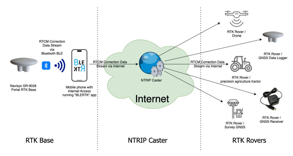
NTRIP RTK technology combines the efforts of an RTK base station, an NTRIP caster, and an RTK rover to achieve centimeter-level accuracy in positioning. Here’s how they work together:
- RTK Base Station: The RTK base station is set up at a known, precisely surveyed location with known coordinates. It receives signals from GNSS satellites and calculates the difference between the observed and actual positions. It then generates correction data that compensates for errors caused by factors like atmospheric conditions and satellite clock discrepancies. This correction data is transmitted to the RTK rover in real-time.
- NTRIP Caster: The NTRIP (Networked Transport of RTCM via Internet Protocol) caster acts as a communication intermediary between the RTK base station and the RTK rover. It receives the correction data from the base station and streams it over the internet to the rover. This allows the rover to access correction data even if it’s at a considerable distance from the base station.
- RTK Rover: The RTK rover is a mobile device equipped with a GNSS receiver that tracks signals from satellites to determine its position. It also receives the real-time correction data from the RTK base station via the NTRIP caster. By combining the signals from the satellites and the correction data, the RTK rover calculates its precise position with centimeter-level accuracy. This process happens in real-time, providing instant and highly accurate positioning information.
The interaction between these components enables the RTK rover to achieve cm-level accuracy by continuously receiving and applying correction data from the base station. This correction process corrects for various error sources, resulting in significantly improved positioning accuracy compared to standard GPS or GNSS systems. The entire system operates seamlessly and in real-time, making it valuable for applications such as surveying, construction, precision agriculture, aviation and navigation.
Compared to traditional GPS/GNSS, RTK is a more complicated technology that relies on real-time correction data to achieve high-accuracy positioning. The diagram below illustrates the flow of correction data using a portable RTK Base as an example.
How Our Products Fit into the NTRIP RTK Architecture?
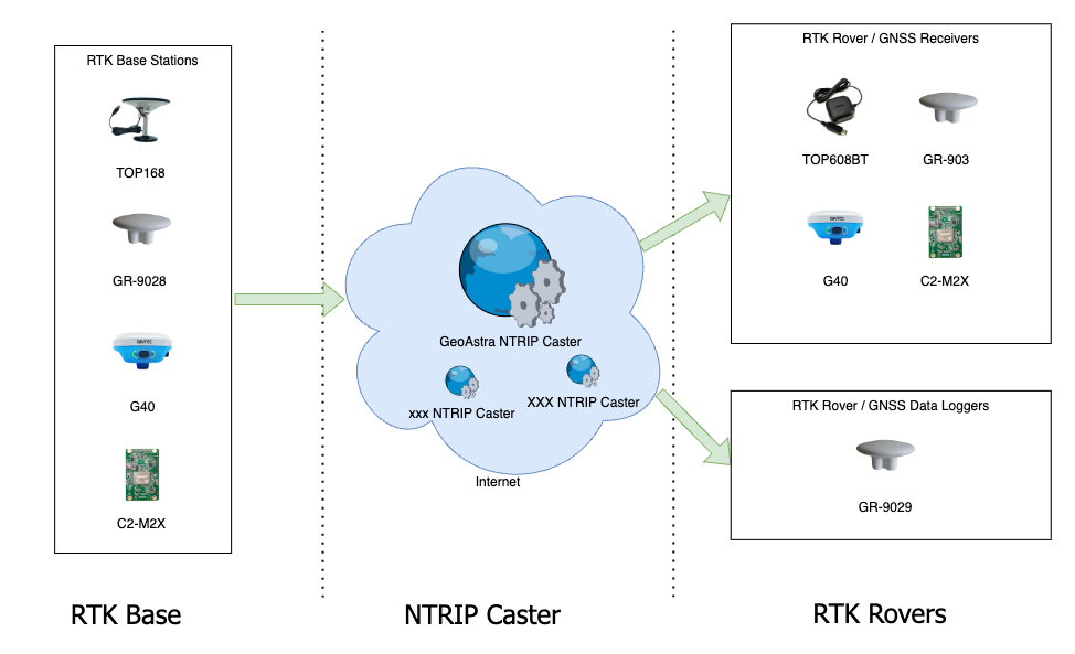
A practical NTRIP RTK solution consists of three main parts: an RTK Base, NTRIP Caster, and RTK Rover. In this section, we will get into how our RTK products seamlessly integrate into each specific parts of this architecture.
RTK Rovers:
We carry the TOP608BT, RTU608BT, RTB609BT, GR-903, G40 GNSS Receiver, C2-M2X GNSS module, Columbus EX-1 and Navisys GR-9029 GNSS Data logger, which seamlessly integrate into the RTK rovers section of the architecture. The key distinctions between them are as follows:
- TOP608BT, RTU608BT or RTB609BT, functions as an RTK GNSS Receiver. Its small, compact size is comparable to a hockey puck, making it ultra-portable and easy to deploy. It is well-suited for use as a Rover due to its portability. However, due to the limitation of its antenna diameter, it is not recommended for use as an RTK Base station.
- RTU609BT is a Heading RTK GNSS receiver equipped with two antennas and two RTK engines. It delivers up to 0.8 cm positional accuracy and 0.2° directional accuracy.
- GR-903 also operates as an RTK GNSS Receiver. Its UFO-shaped antenna enables it to receive stronger signals compared to hockey puck-sized receivers. This model is versatile, suitable for use both as an RTK Rover or Base Station.
- G40 is a triple-band, survey-grade receiver that can be used both as a rover and a base station. It offers superior performance, but as expected, it comes at a higher price compared to other non-survey GNSS receivers.
- C2-M2X is a triple-band GNSS module that can be configured as a USB RTK GNSS receiver for both rover and base station use. It’s important to note that the C2-M2X is primarily intended as a development kit, rather than a production product. It lacks Bluetooth connectivity and is equipped with only 2 USB interfaces.
- EX-1 or GR-9029 serves as an RTK GNSS data logger, allowing for the recording of tracks and waypoints into data files.
NTRIP Casters Services:
Setting up and managing an NTRIP Caster can be complex, requiring extensive knowledge of RTK and computer systems, as well as maintaining a server operating 24/7. For most users, utilizing an existing NTRIP Caster service is likely the most practical solution.
GeoAstra, a subsidiary of CanadaGPS, has recently launched its NTRIP Caster service, providing production-grade NTRIP services to the public. It offers free, pro, and enterprise subscription plans to suit different usage scenarios. Check it out at www.geoastra.com.
In addition to our GeoAstra NTRIP Caster service, there are several other NTRIP services provided by third parties, such as rtk2go and Emlid. You can find the latest information on their official websites.
Compared to these third-party NTRIP services, even the free plan of GeoAstra offers a fully-featured, commercial-grade NTRIP service without any reduction in functionality or connection time limitations. This is one of the significant advantages of using GeoAstra NTRIP Caster.
RTK Base Stations:
Our selection includes the GR-9028, TOP168, G40, GR-903 and C2-M2X tailored for the RTK Base segment within the architecture. The primary distinctions between them are as follows:
- GR-9028 is a portable RTK base, designed for easy and quick deployment at any location. It includes an iOS/Android app for rapid setup, allowing it to become operational within minutes.
- TOP168 and Columbus EX-1 are fixed RTK bases, intended for permanent installation at specific locations. It boasts a larger antenna, higher waterproof rating, and broader working temperature range compared to the GR-9028. However, it lacks an app for quick setup.
- G40 is a survey-grade, triple-band RTK GNSS receiver suitable for use as an RTK Base. It typically captures more valid satellites than dual-band RTK bases, providing higher quality correction data to rovers. The primary drawback of the G40 is its cost.
- GR-903 also operates as an RTK GNSS Receiver. Its UFO-shaped antenna enables it to receive stronger signals compared to hockey puck-sized receivers. This model is versatile, suitable for use both as an RTK Rover or Base Station.
- C2-M2X is a triple-band GNSS module configurable as a USB RTK GNSS receiver for both rover and base station applications. It’s crucial to note that the C2-M2X is mainly a development kit and not a finished product. It does not feature Bluetooth connectivity and comes with only two USB interfaces.
As we continue to expand our product range, we will introduce more offerings to our customers in the near future. Stay tuned for updates to this document.
Thank you and best regards,
Jack Wu
Director,
GPSWebShop
RTK GNSS can be purchased from:
https://gpswebshop.com (US & WorldWide)
https://canadagps.ca (Canada)